| Funding for abandoned mine land reclamation (AMLR)
comes from fees paid by active coal mining companies. Congress decides how
much of the $300M in fees, paid by active coal mining companies each year,
will actually be used to perform AMLR work. With this funding, the Office
of Surface Mining allocates AMLR funds to states based on the tonnage of
coal mined today, provided that the respective state regulates active mining
in that state. |
| Prior to the late 1980’s, Tennessee qualified for AMLR
funding and several large AMLR projects were completed. One such project
was the construction of a tied-back wall to stabilize a landslide that
impacted a county road and railroad in Scott County, Tennessee. After the
slide was stabilized, the state later appropriated tax dollars to construct
a bridge across New River at this location to replace a foot bridge. The
state could not have built the bridge except for the fact that AMLR funding
was first used to stabilize the landslide. Folks that live on the opposite
side of New River from the county road can now drive to their homes rather
than having to park along the county road and walk to their homes. The
return on the AMLR funding investment multiplied. |
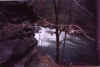
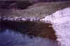
Click on image to enlarge:


Completed tied-back wall to
stabilize landslide (17 years
after completion with new bridge
across New River replacing
previous foot bridge)
|
| In the late 1980’s, Tennessee decided to give
up its regulatory program and allow OSM to regulate coal mining in Tennessee
at the federal level. As a result, Tennessee no longer qualifies for AMLR
funding. Other coal-producing states regulate mining at the state level
and they are rewarded with AMLR funding from OSM. Other states have
recognized that many of their abandoned mine land problems can be solved by
re-mining and reclaiming previously mined areas in accordance with modern
standards outlined in the Surface Mining Control and Reclamation Act (SMCRA).
Not only is water quality improved on the re-mined area, but fees paid into
the reclamation fund for the coal that is mined can be used by that state to
reclaim abandoned mine land that is not suitable for re-mining. |
|

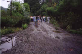
Congressman Zach Wamp, Barry Thacker PE, Rep.
William Baird, County Executive Rex Lynch,
and Project Impact Coordinator Mark (Hollywood) Whaley during field
trip
to an abandoned deep mine discharge site. |
The funding that Tennessee now receives from OSM is a hand-out.
OSM is not obligated to give Tennessee any AMLR funds. Our meager state funding
is appropriately used to address abandoned mine land (AML) problems that
directly impact public safety. As a result, if we want abandoned mine land
reclamation work done to improve water quality and reduce flooding, then we are
going to have to do it through non-profit organizations like the Coal Creek
Watershed Foundation.
|
| Restoration of the Black Creek watershed in Wise County,
Virginia, shows the difference between AMLR work in Tennessee and Virginia.
Black Creek is impacted by surface and underground mines abandoned prior to
1977. Coal mine drainage from abandoned deep mines flows into Black Creek and
then into the Powell River, which is a put-and-take trout stream. An existing
wetland, formed by a beaver dam in Black Creek, provides treatment for the coal
mine drainage most of the time. However, during floods, the beaver dam overtops
and iron precipitate is washed into the Powell River (sound familiar?). The
latest Awashout@
of the beaver dam occurred in June 2000. |
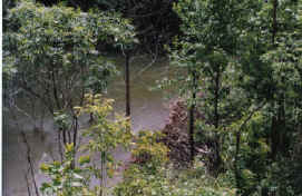
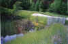
Black Creek wetland cell No. 1 is created by a
beaver dam that "washes out" during heavy rains. |
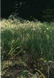
Wetland vegetation in Cell No. 1
|
In Black Creek, the Virginia Division of Mined Land Reclamation
(DMLR) worked out a deal with a local coal company. Abandoned mine lands in
Black Creek will be re-mined over the next 10 years. Incentives were given by
DMLR to close the re-mining deal. Water quality will be improved as a result of
the re-mining. |
| In addition to re-mining, flood control structures were
recently built
downstream of the beaver dam (i.e. Outlet Control Structure No. 1) and at an
upstream road crossing (i.e. Outlet Control Structure No. 2). The outlet control
structures allow the existing wetland areas to flood temporarily during
storm events and reduce the potential for iron precipitate to be scoured. They
also address the problems with the beaver dam being "washed out"
during flood events. Pipes
installed through the outlet control structures slowly decant the stored
water. Between flood events, water levels in the wetland areas will be
controlled by the beavers. |
CLICK ON IMAGE TO ENLARGE
Plan view of Black
Creek Outlet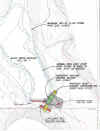 Control Structure No. 1
built downstream of the
existing beaver dam. Control Structure No. 1
built downstream of the
existing beaver dam. |
Completed Wetland Photos:
Click on image to enlarge
|
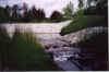
 Powell
River (trout stream) to be protected by the Black Creek Watershed
Restoration Project. Powell
River (trout stream) to be protected by the Black Creek Watershed
Restoration Project.
|
|
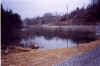
 Completed
Outlet Control Structure No. 1 built downstream of existing beaver
dam. Wetland will be temporarily flooded during storm events to
reduce the potential for scouring of iron precipitate from wetland. Completed
Outlet Control Structure No. 1 built downstream of existing beaver
dam. Wetland will be temporarily flooded during storm events to
reduce the potential for scouring of iron precipitate from wetland.
|
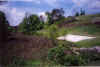
 Wetland
Cell No. 2 upstream of Outlet Control Structure No. 2 with raised county
road at right of photo. Wetland
Cell No. 2 upstream of Outlet Control Structure No. 2 with raised county
road at right of photo.
|
|
 Armorform-lined
spillway of Outlet Control Structure No. 2 discharging into wetland cell
No. 1. Armorform-lined
spillway of Outlet Control Structure No. 2 discharging into wetland cell
No. 1.
|
 Submerged
outlet of decant pipe to reduce potential for beavers to crawl up pipe and
dam up inlet. Submerged
outlet of decant pipe to reduce potential for beavers to crawl up pipe and
dam up inlet.
|
|
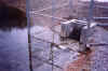 Porous
rockfill base and fence at decant pipe inlet. If beavers try to dam
up around fence, water can flow through rockfill under fence to keep
wetland at current level. Porous
rockfill base and fence at decant pipe inlet. If beavers try to dam
up around fence, water can flow through rockfill under fence to keep
wetland at current level.
|
 Armorform-lined
plunge pool downstream of Outlet Control Structure Armorform-lined
plunge pool downstream of Outlet Control Structure
No. 1.
|


 Control Structure No. 1
built downstream of the
existing beaver dam.
Control Structure No. 1
built downstream of the
existing beaver dam.